- Details
- Written by Gordon Prentice
It is standing room only in the Council Chamber last Thursday (5 April) as a team of people from Metrolinx unveil their plans for the proposed new GO Rail Station at Mulock Drive.
Grade separation has been abandoned. That is a humungous change from the original concept when road and rail on Mulock Drive would be separated. 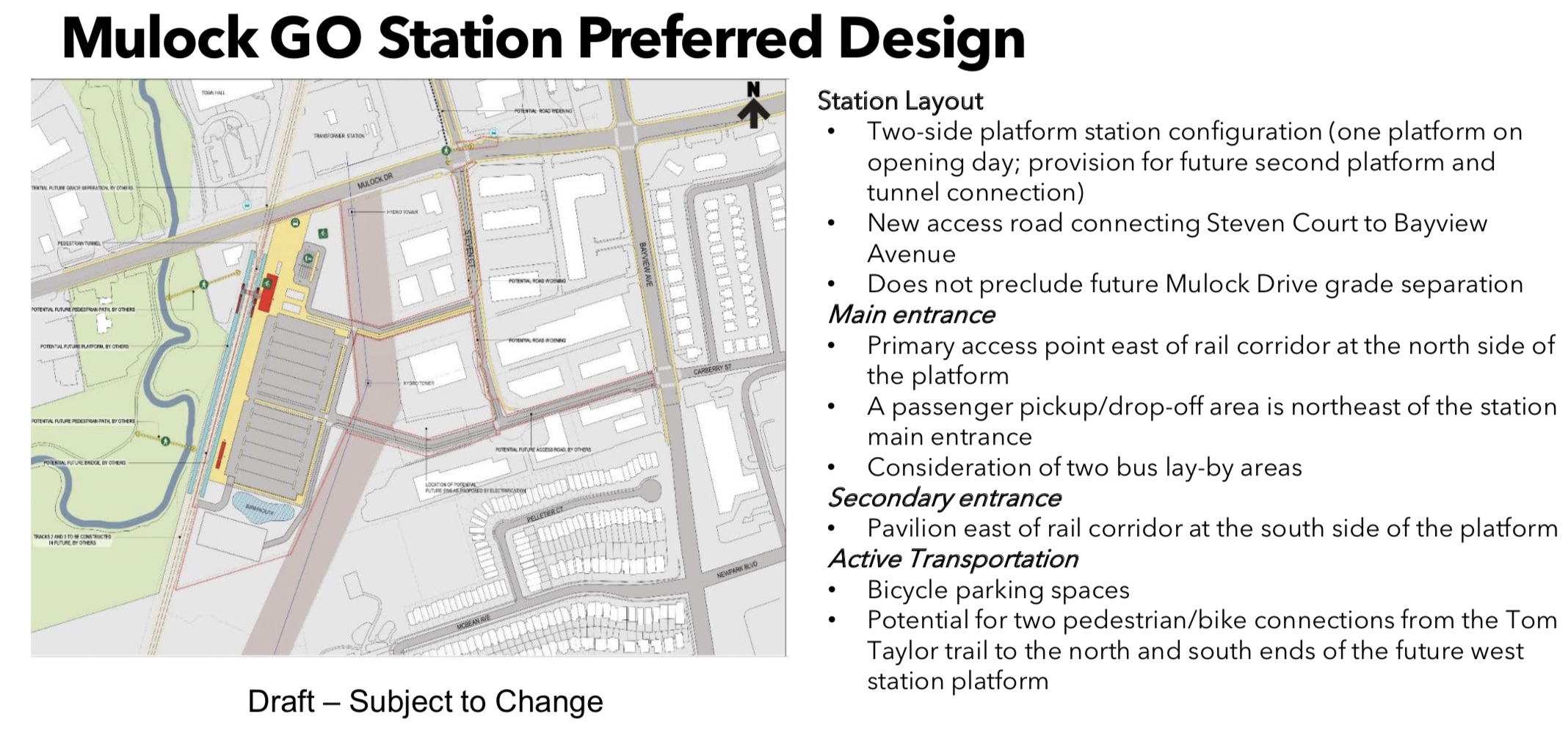
There are also plans for more parking. Up from the original 550 spaces.
The evening starts with the Town’s senior planner Adrian Cammaert conversationally setting the scene and introducing the Mayor and councillors to the audience. He gets to Dave Kerwin who is perched at the back of the public gallery, leaning forward on the edge of his seat like an ancient gargoyle. And Adrian blanks!
How is this possible? Kerwin is unforgettable.
Those of us who have been victims of his trademark cloying flattery shout out.
“That’s Dave Kerwin!”
It’s not about trains. It’s about parking.
Now the Metrolinx people are introducing the station plans to the crowd drawn largely from the immediate locality. They broadly divide into two categories. Those who want more parking and those who are concerned about all the traffic at peak times clogging up the roads and infiltrating residential streets looking for short cuts.
The questions come thick and fast. I need a map on my lap to keep up. What about the proposed new access road to Steven Court? What about the business owners who currently park there? The man who is gonna lose his parking is exasperated:
“This whole thing to me is ridiculous!”
Now someone wants to widen Mulock and Bayview to accommodate the increased traffic making for the station’s 700 parking spaces.
Now we are on to a question about parking at East Gwillimbury. No-one seems to know how many new parking spaces are being created there. An assertive John Taylor rises to his feet, making sweeping gestures with his outstretched arm, demanding figures by the end of the meeting! Whatever happened to Mr Reasonable? The man who bends over backwards to be accommodating. Is he back on the double espressos?
Now someone is ridiculing walking and cycling as a means to get to the station. (The professionals call walking and cycling “active transportation”.) 
He says
“This is Newmarket!”
and gets gales of laughter.
Soon we are hearing about “sweaty joggers”. And suggestions that shuttle buses could take comfortably crisp and dry commuters from parking at the Magna Centre (where there are lots of empty parking spaces during the day) to the new station.
Now we are back to Silken Laumann where people are worried about train whistles. Metrolinx has been asked this question about whistles a million times and the response, endlessly rehearsed, is polished. Federal regulations etc etc. Toronto has gotten rid of whistles but, as a quid pro quo, takes over liability for whatever tragedy may happen as a result of their absence.
The Wind and the Whistles
I learn the prevailing north-west winds carry noise into Silken Laumann. There are calls for a sound barrier but it is not on offer.
The audience throws questions at the Metrolinx people about journey times, double tracking and express trains and much else. We are told the answer is to be found in some other study which is not on the table for discussion this evening or the Metrolinx people present don’t know the answer. Traffic management, for example, is a matter for the Town.
Adrian Cammaert, memory back and sharp as a blade, says everything’s covered. Traffic studies are part of the new Secondary Plan for Mulock Drive.
Nothing to worry about then.
gordon.prentice@shrinkslessorsquare
Metrolinx calls time on free parking at GO Rail stations.
- Details
- Written by Gordon Prentice
Late in the evening, Morad Dadgar's Monster House at 1011 Elgin Street floods the dark residential street with light. And there are still more LEDs to be attached to the front of the building.
This is a house that glows in the dark. 
Does the Town have any by-laws on light pollution?
Is it OK to subject next door neighbours to this brilliant display at any time of the day or night?
1011 Elgin Street featured in the recent Council Workshop on "Intensification in Stable Residential Areas". Astonishingly, it meets all the Town's rules and regulations. The crazy zoning by-laws say it is permitted to build such a huge structure in a street full of bungalows and modest two storey homes.
Years ago, the Town's most senior planning staff anticipated this kind of mega development. They knew it was coming unless they acted. But they sat on their hands, gazing out of the window. Doing nothing.
Councillors can choose to be guided by the Town's Director of Planning or by their own commonsense.
Would they want to be living next door to this dazzling confection of a building or not?
Paddytown
Tomorrow (9 April) councillors will consider a staff report on Paddytown, a stable residential neighbourhood.
Before slavishly following the staff recommendation, they should ask themselves if the proposed development of six semi-detached houses fits in - using the very same criteria they favoured on 26 March 2018 in the Council Workshop on intensification in stable residential neighbourhoods.
This email address is being protected from spambots. You need JavaScript enabled to view it.
- Details
- Written by Gordon Prentice
Last night (5 April 2018) Christine Elliott’s meet and greet in Newmarket had an unwelcome guest, the former PC candidate Charity McGrath. 
Three weeks ago McGrath was stripped of her status as official PC candidate for Newmarket-Aurora for cheating in the 2017 nomination.
CTV reporter Mike Arsalides tells us:
“Some hoped she’d skip the event after some reports that McGrath and her team falsely signed up seniors and veterans without their knowledge.”
He corners McGrath:
“Some people have questioned what has happened with you and now Christine parachuting in. What do you have to say to those seniors who feel swindled?”
McGrath looks at him but says nothing. You can see the cogs in her brain engage then disengage. She purses her lips. It is painful to watch.
I am left wondering if McGrath is going to have any role in the PC campaign. Is she going to be knocking on doors for Christine Elliott? Is she going to be working the phones for the former MPP for Oshawa? Will she nominate Elliott? Can she? Is she an eligible voter?
On the CTV clip I learn from a PC member that Oshawa is “somewhat similar” to Newmarket-Aurora. Hmmm. 
Does Christine Elliott really want voters to be reminded of the disgraceful shenanigans that led to her becoming the PC candidate for a riding which is a million miles from Oshawa?
Elsewhere… Doug Ford abandons the Campaign Bus.
Doug can run but he can’t hide.
And if he has nothing to say we shall find out soon enough.
This email address is being protected from spambots. You need JavaScript enabled to view it.
update on Saturday 7 April 2018: Newmarket's Lisa Heckbert confronts Christine Elliott demanding an assurance that people recruited fraudulently by Charity McGrath will be removed from the Newmarket-Aurora membership list.
To see CTV piece open Link in 3rd paragraph above and scroll to 11pm news on 5 April 2018.
- Details
- Written by Gordon Prentice
It is touch and go whether the proposed new GO Rail Station at Mulock Drive will ever materialise. 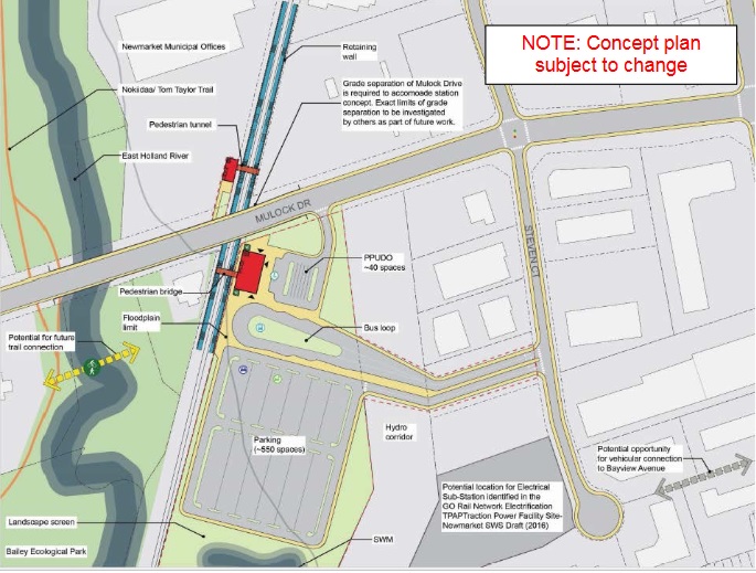
At the last Metrolinx Board meeting on 8 March 2018 there were questions about Mulock and whether the negatives outweighed the positives. As I listened to the debate unfold the omens didn’t sound too good. The Board will make a decision on the definitive list of new rail stations by October.
The Initial Business Case (IBC) in 2016 found:
“the Mulock station supports a few of the Strategic, Financial and Economic criteria for new stations and none of the Operations and Deliverability Case criteria. These results, which include high capital costs, negative net-present value (NPV) and significant construction challenges, are largely attributed to the requirement for a rail overpass and the proximity of the rail and station lands to the East Holland Creek, a Hydro corridor and established businesses.”
For all that, there is no doubt in my own mind that Newmarket needs a new GO Rail Station at Mulock - coupled with a 15 minute service extended northwards from Aurora. This changes all the metrics.
“happy dance”
When Newmarket Mayor, Tony Van Trappist, learned that Metrolinx was planning a new station at Mulock he told residents they should do a “happy dance”. As is his way, he then let events take their course instead of pushing mightily for the 15 minute service to be extended a couple of miles north from Aurora to Mulock.
At the 8 March Board meeting, Metrolinx abandoned grade separation which was previously deemed essential.
“The feasibility of the Mulock station concept is contingent on the grade separation of Mulock Drive, with a multi-span bridge over both the rail corridor and the East Holland River.”
Without grade separation we shall have to live with the old level crossing, slowing down traffic on one of the Town’s busiest roads.
Grade separation and the cost of doing nothing
Obviously Metrolinx cannot do grade separations all the way up the Barrie line. It would cost an arm and a leg. But doing nothing on major arterial roads like Mulock will in the long run cost more. And land will still have to be safeguarded for future grade separation as the population grows here in Newmarket and in East Gwillimbury.
I’ve asked Metrolinx when we can expect to see the results of their Review of Level Crossings. Perhaps we shall hear more about this tonight.
Back in 2016 Metrolinx said the proposed new station
“conforms to broad transportation and planning policies but does not currently align with the Town of Newmarket’s policies for where growth and higher density development should be located”
It didn’t meet the density targets for Regional Rail with only 35 to 40 people and jobs per ha within 800 m of the station. At long last the Town is now embarking on a Secondary Plan for the Mulock Area – and, inevitably, bringing in outside consultants - to see if that density can be revised substantially upwards.
The Town has got to get fired up about the Mulock Secondary Plan and sell its vision to Metrolinx who will, by October, be looking for reasons to keep Mulock in the programme – or not.
Metrolinx Open House tonight 5 April 2018
Tonight Metrolinx will be hosting an Open House on the proposed new station to get feedback from local people. It will be held at the Council Offices at 395 Mulock Drive from 6.30pm-8.30pm with a presentation at 7pm.
This email address is being protected from spambots. You need JavaScript enabled to view it.
- Details
- Written by Gordon Prentice
Now we can get a full frontal in-your-face view of the Monster House at 1011 Elgin Street. 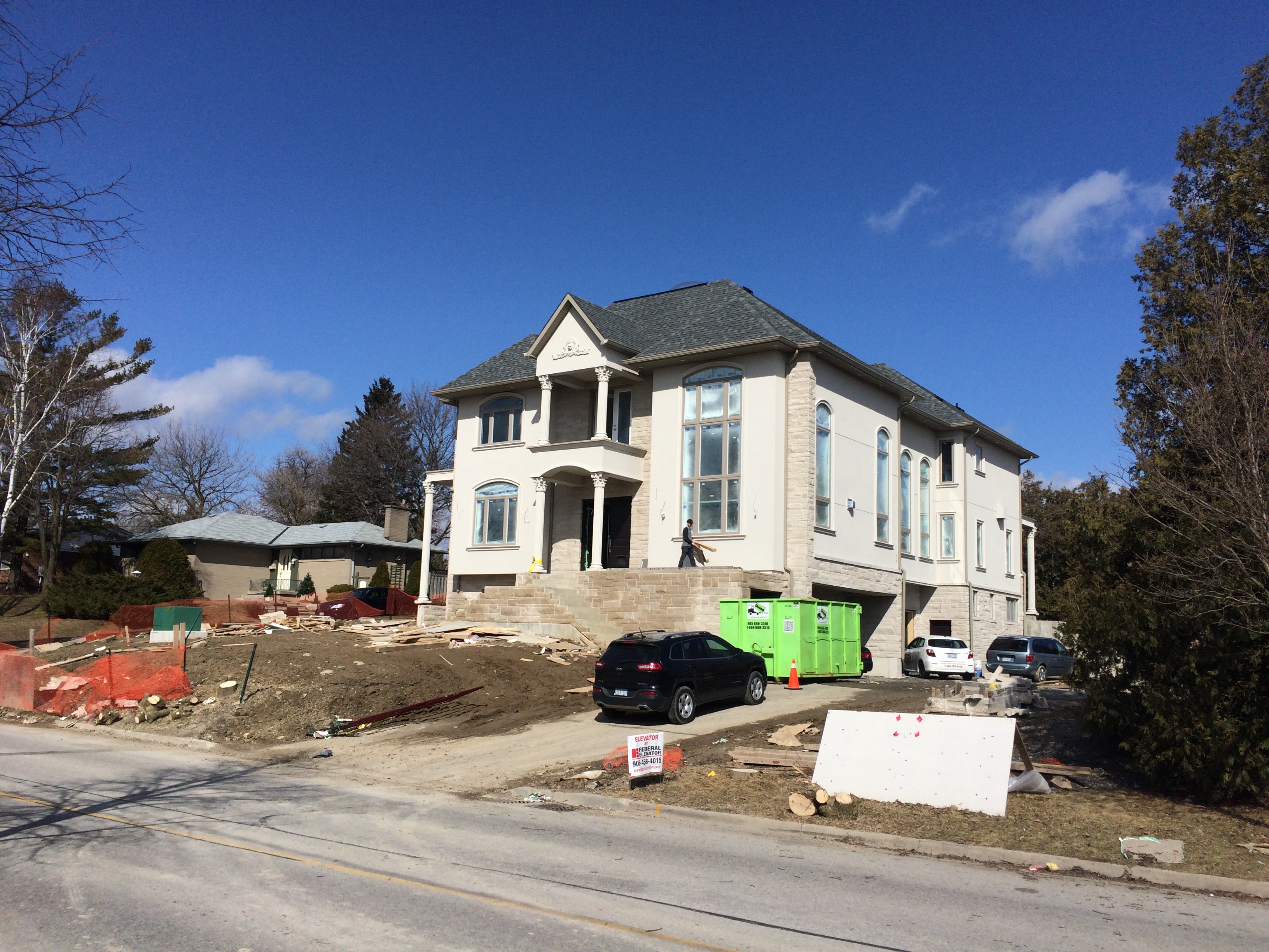
On Monday (2 April) the tree inconveniently situated in front of the house was chopped down on the orders of the owner, Morad Dadgar.
It is clear beyond any argument that the Town has signally failed to protect the neighbourhood from this towering structure which now dominates the street. It even has LED lights under the eaves so we can expect the exterior to be floodlit at the flick of a switch any time the owner chooses.
At last week’s Council Workshop on “intensification in stable residential areas” (26 March 2018) councillors considered possible new approaches to the Town’s Zoning By-laws that would offer some kind of protection to existing residents.
The longest serving councillor in Canada, the inquisitive Dave Kerwin, innocently asks Senior Planner, Dave Ruggle, if another giant house could be built alongside 1011 Elgin.
Yes says the planner. The house meets Town’s the zoning standards.
Useless by-laws
The Town’s zoning by-laws are so useless that there is nothing to stop Mr Dadgar or one of his relatives from tearing down the bungalow next door - which they also own - and building Monster House 2.
Kerwin’s colleague and Council jewel, Bob Kwapeese, is concerned about what may happen across the Town between now and when any new Zoning By-law regime is brought it. He says there is already a rush to sever lots to squeeze in more new developments. Dave Ruggle says if the Council wants to stop any development it could issue an “Interim Control By-law”.
Oh no no! says Van Trappist, the developer’s friend.
“That would be the nuclear bomb option!” 
If a Monster House was gonna be his next door neighbour in London Road the old banker’s finger would already be hovering over the nuclear button.
A long list of councillors line up to express regret or concern about 1011 Elgin Street and its impact on the neighbourhood. Ward councillor Jane Twinney says it doesn’t fit in. John Taylor says it boggles the mind that the Monster House occupies less than 35% of the total lot area – as required by the Zoning By-law.
Emerging issue
Tom Vegh talks fancifully about infill development as an “emerging issue”. As if the Town is cleverly taking steps to address a problem which is only now manifesting itself. Complete baloney! This was an issue the rest of us – including the Director of Planning in 2012 - could see coming.
Christina Bisanz talks of protecting the character of residential areas. She hopes this protection will not just apply to neighbourhoods of her vintage or older! She makes the case for protecting newer neighbourhoods from inappropriate infill.
We are told that within 60 days the planners will be ready to present a report to Council on how best to tighten up the Zoning By-laws to stop developments like 1011 Elgin from blighting entire neighbourhoods.
Taking it all on trust. 
Councillors are told by the planners that 1011 Elgin Street meets the Zoning standards and we take that on trust. We still haven’t seen the height and the lot coverage independently verified by a qualified Ontario surveyor but that’s not going to happen unless councillors insist on it. It’s not on the cards.
Ages ago the Director of Planning, Rick Nethery, asked the owner, Morad Dadgar, to let the Town have sight of the property survey but he, Nethery, was ignored.
If not, we would have been told about it.
As it is, no-one takes responsibility for the Monster House at 1011 Elgin Street.
No-one goes nuclear.
It’s just one of those things.
This email address is being protected from spambots. You need JavaScript enabled to view it.
Page 158 of 288