On 14 December 2021 the Town gave a Donation (or Tax) Receipt for $14,290,000 in exchange for a 15.92 acre parcel of land at Glenway West which was gifted to the Town by Marianneville who didn't want it. The donation was agreed and publicized with great fanfare in June 2017. The title would transfer at a time of the Town’s choosing. 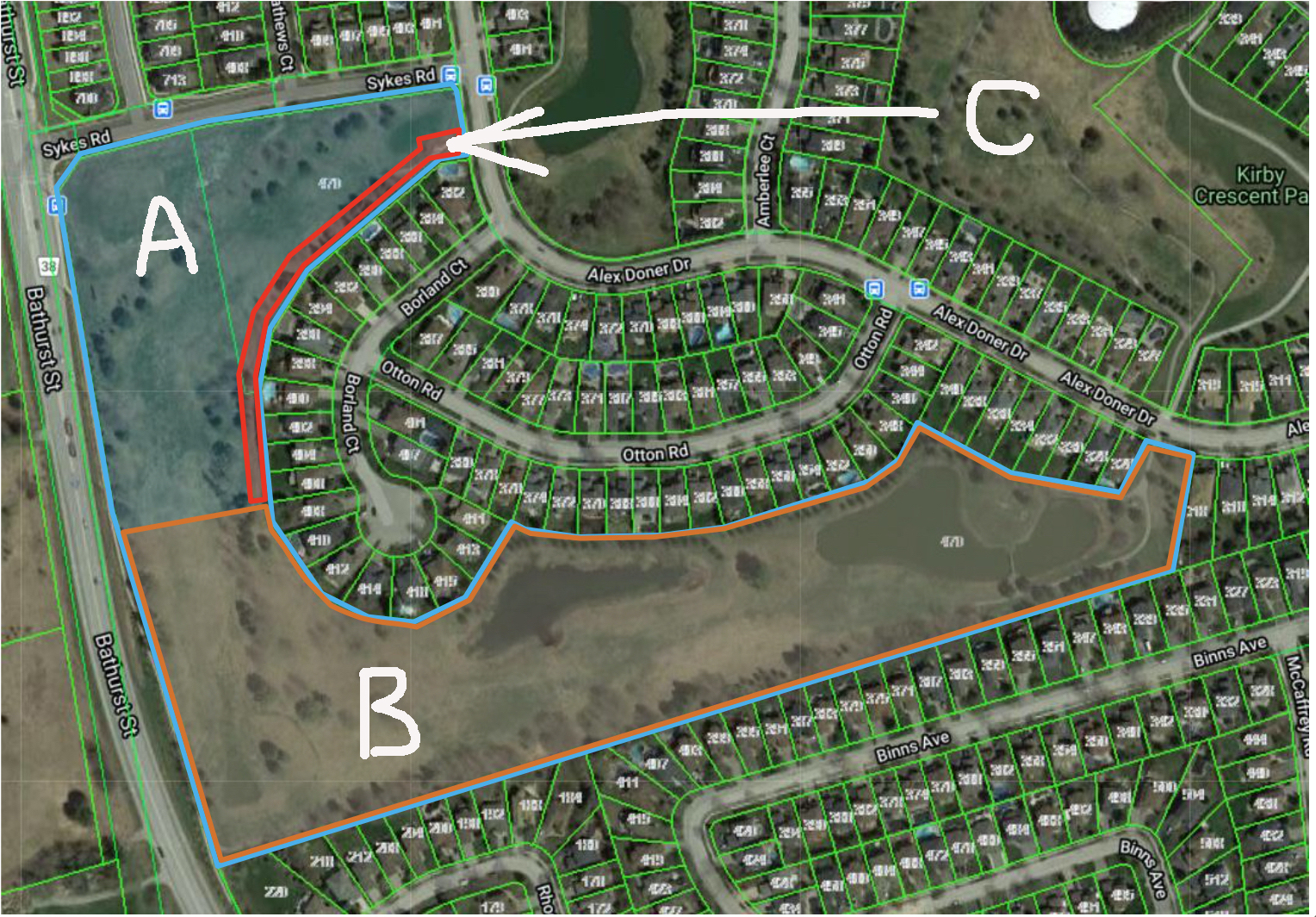
A tax receipt issued in exchange for a charitable donation can be used to offset taxes owing to the Canada Revenue Agency. It is as good as real money.
Background: The 140-acre golf course at Glenway was bought by the developer Marianneville on 21 January 2010 for $9,900,000 – around $71,000 per acre. The then owner - Glenway Country Club (1994) Limited - had offered it to the Town in 2008 but the Town wasn’t interested. Marianneville then went to the OMB in 2014 to get the golf course zoning changed from private open space to allow residential development. They succeeded.
The Mayor at the time, now Newmarket-Aurora’s Liberal MP, Tony Van Bynen, said the Town had stood shoulder to shoulder with local residents, valiantly fighting at the OMB to defend the Town’s Official Plan which showed Glenway as open space. This version of events is a complete fiction. The then Director of Planning, Rick Nethery, said the Town did not defend the Official Plan at the OMB. In fact, the Town’s planners boycotted the hearings and the Town’s case was put by an outside planner with limited knowledge of the Town’s planning policies and history.
Two Issues
Fast forward to December 2021… How did the land donation translate into a tax receipt for $14,290,000? There are two issues here (a) the rules which apply for offsetting tax otherwise owed to the Canada Revenue Agency and (b) whether the donated land could realistically be developed for medium density housing as suggested by the valuers, giving it a market value of over $14M.
The CRA rules on charitable donations of real property (ie land)
The CRA has strict rules which govern donations to charities (whose definition includes municipalities). The gift must be irrevocable and come with no strings attached. Crucially, the CRA needs to know the fair market value of the property at the time the gift was made.
The valuers estimated the fair market value of the donated lands on 26 February 2021:
“Any estimate of Market Value concluded in this Appraisal Report is based upon market conditions as (sic) the Effective Date of Valuation (ie 26 February 2021). This Appraisal Report does not provide a prediction of future or prospective Market Value.”
The donation receipt (and, presumably, the transfer of title) was made nine months later, on 14 December 2021.
The Valuers say their estimate of $14,290,000 is the most probable price the property could achieve “after reasonable exposure in a competitive market…” The Appraisal Institute of Canada says the concept of “reasonable exposure time” includes adequate, sufficient and reasonable marketing effort. It begs the question – how would the donated land, open space with two storm water ponds, be described and marketed? They would be marketed as land theoretically ripe for development. But they are not.
Donation Policy 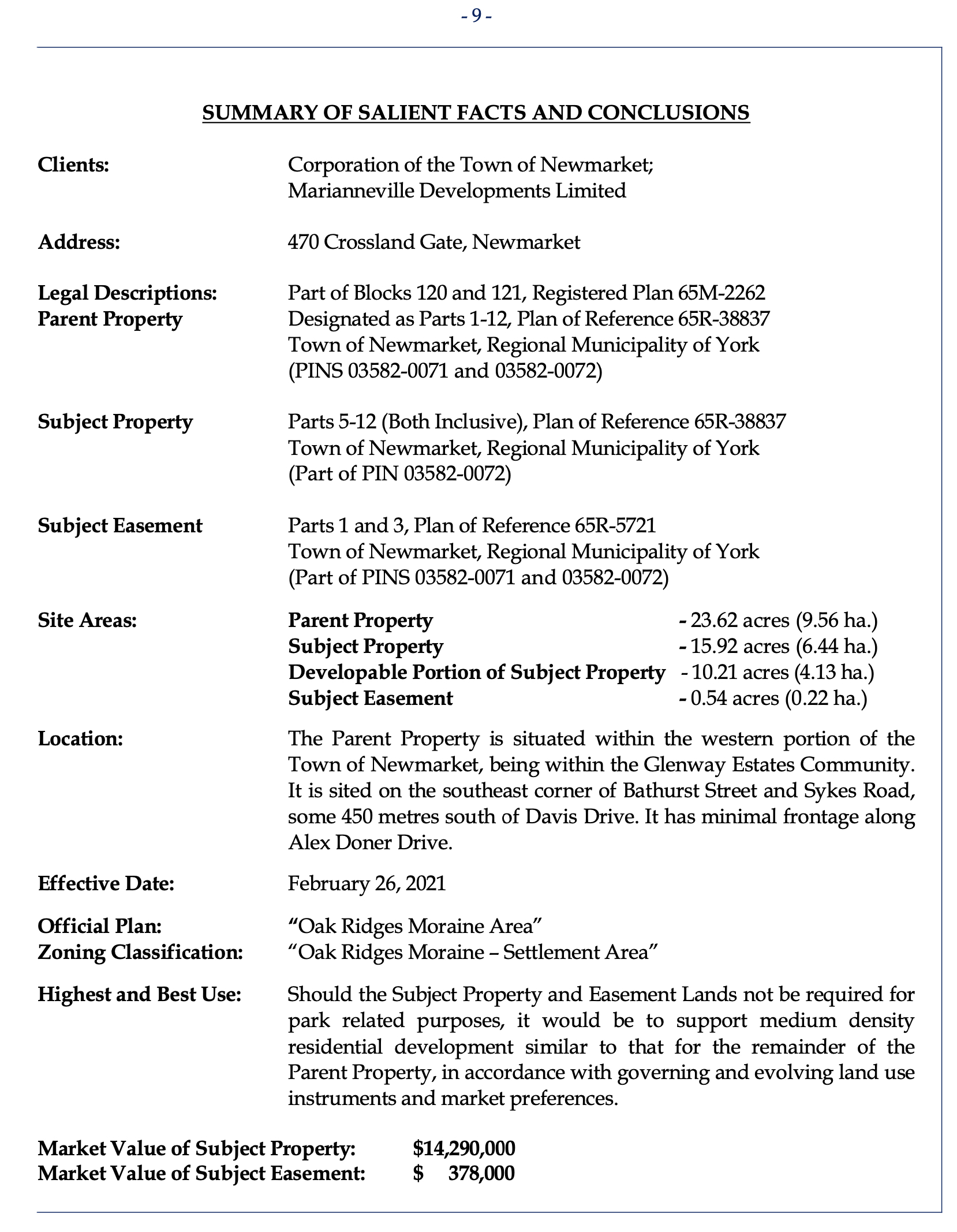
The Town accepts gifts in line with its donation policy. It says:
“Donations will not be accepted from persons who have a concurrent application of a permit or license from the Town or an application for planning approval from the Town, or from persons who are bidding for a contract from the Town through a procurement process.”
After the OMB’s decision in 2014, the Town and Marianneville were locked in an embrace, whether they liked it or not. Development was going to happen but the terms still had to be negotiated.
On 7 June 2017 the Town announced that an agreement had been reached with Marianneville who had decided to donate 16 acres of land around the former golf course’s 16th hole for public open space.
Gift of land separate from planning approvals
The Town emphasised that the donated land and any planning applications to develop the Glenway lands were to be regarded as completely separate. In their agreement on 9 May 2017 Marianneville acknowledged
“…that the terms of this agreement do not constitute in any way an approval of any future development proposal for any part of the lands known as the former “Glenway” lands, and that the owner shall still be required to proceed with the normal approval process for any future development of these lands.”
However, there was one thing that Marianneville wanted from the Town – a Tax Receipt.
“In consideration of the conveyance of the Lands and Stormwater Management Lands to the Town, (ie the donated lands) The Town agrees to provide a tax receipt to the Owner, as permitted under guidelines by the Canada Revenue Agency, reflecting the fair market value (FMV) of the (donated lands) and to place a recognition plaque within the (donated lands) acknowledging the donation of these lands to the Town.”
“The FMV will be determined by an appraisal of the Lands jointly commissioned by the Town and the Owner…”
The Valuers say their Report was commissioned:
“to assist in asset valuation related matters.”
Plainly, its primary purpose was to facilitate a Tax Receipt for the developer.
But is the land worth $14,290,000?
This is the second issue.
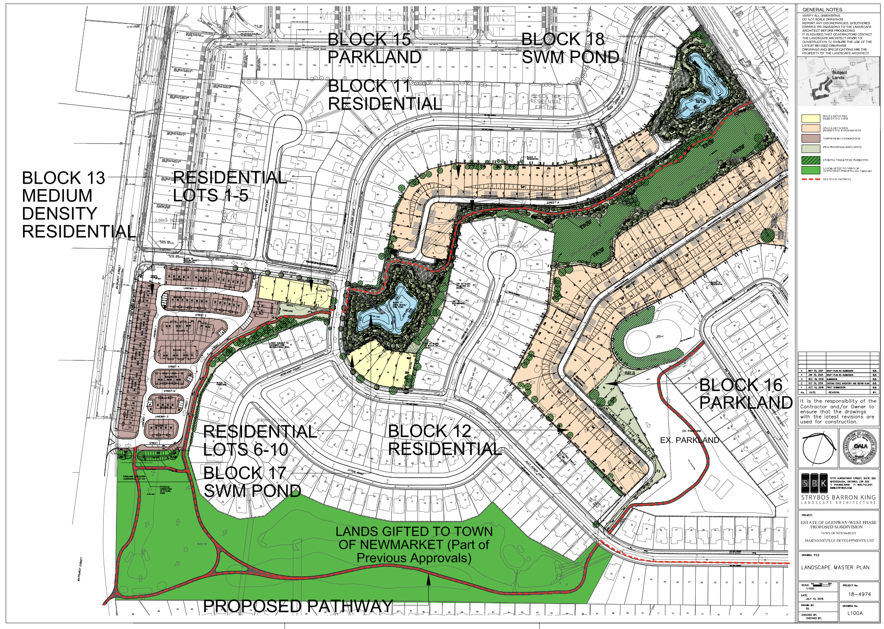
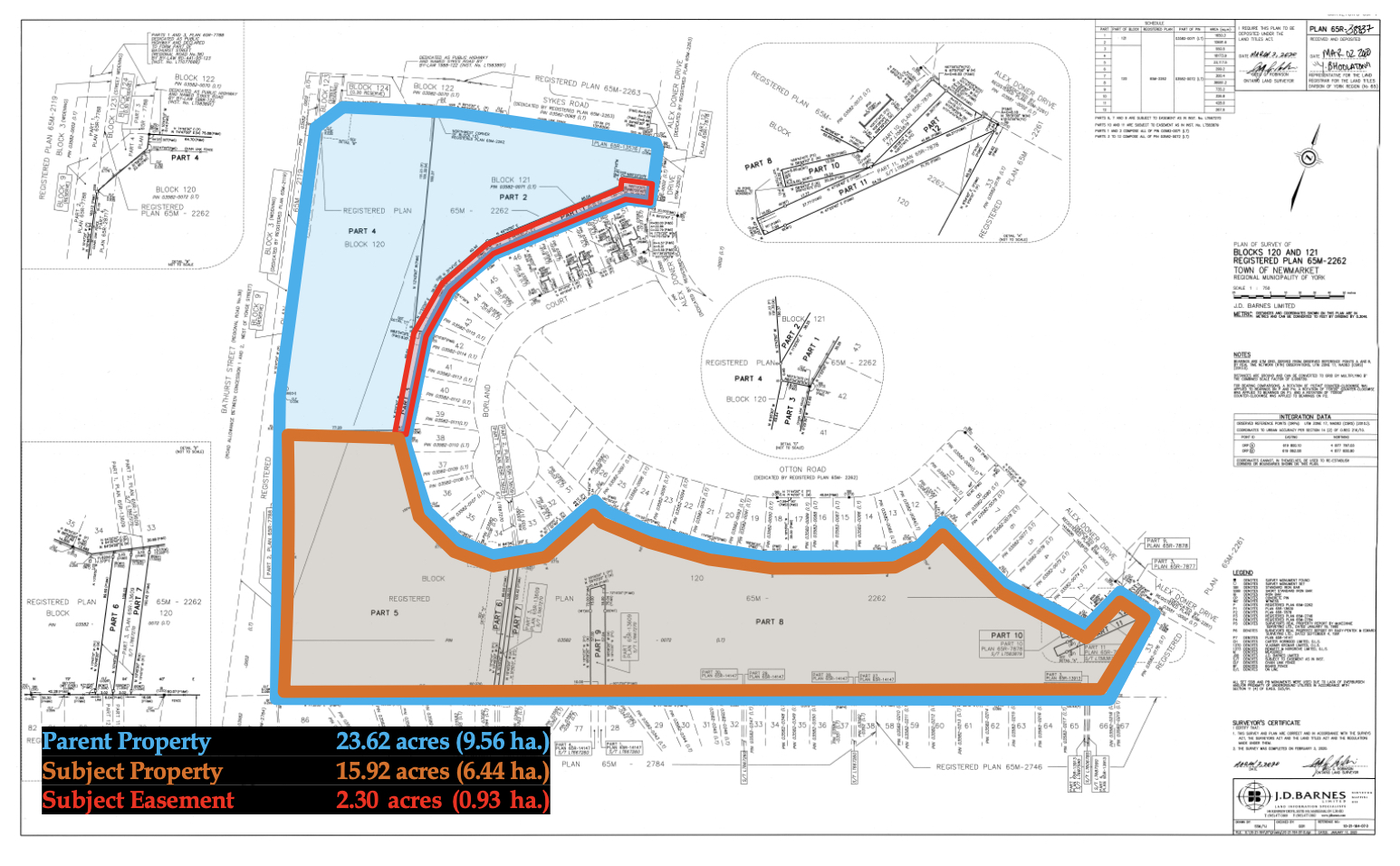
The donated land is in the Oak Ridges Moraine and is zoned as Open Space. It is marked “B” on the plan above and is referred to as the “subject property” by the valuers.
It lies directly to the south of a block earmarked for Townhouse development (marked as “A” on plan). Together “A” + “B” + “C” (an easement "C" allows for a proposed trail to loop through the new development) constitute the so-called “parent property”.
Marianneville’s Joanne Barnett told Newmarket Today on 30 December 2021 that the donated lands around the former 16th hole of the golf course worked for a trail system but were less suitable for housing:
“They supported two stormwater ponds and segued nicely into the woodlot there. It was a nice fit.”
But the valuers, commissioned jointly by the developer and the Town - with a brief to estimate the fair market value of the donated land should it “not be required for park related purposes” - say the land is suitable for medium density residential development.
Market Value for the Highest and Best Use of the land
To get the estimated market value, the valuers chose to compare the townhouse block “A” with its planned 96 townhouses to the donated block “B”. They say their appraisal report has been:
“completed in accordance with the Canadian Uniform Standards of Professional Appraisal Practice as adopted by the Appraisal Institute of Canada.”
The Institute says that when giving an opinion on the “Highest and Best Use” of a property the appraiser should give an opinion
"on the land, as if vacant, and the property, as improved"
Here, the valuers only give an estimate of the donated land as developed – not as undeveloped open space.
The Institute says that providing an estimate of market value for the land alone depends on the "scope of the assignment".
Stormwater Ponds
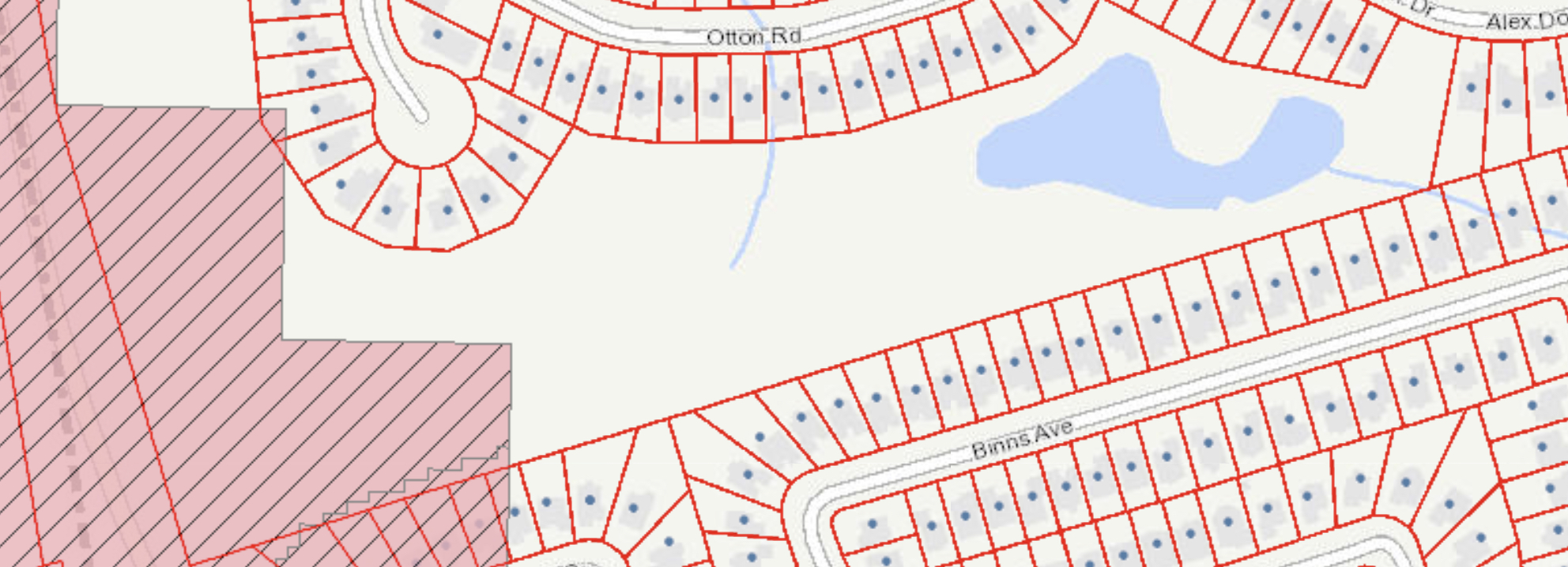
The donated land sits, in part, on a Significant Water Recharge Area and contains two large Storm Water Ponds. It is surrounded on three sides by a long-established residential neighbourhood characterised by single detached houses. The valuers say that of the 15.92 acres 10.21 are developable.
“Part 5, Plan of Reference 65R-38837 has an area of 5.71 acres and represents lands intended for green space or other municipal purpose. For the purposes of this Report, these lands are assumed to be non-developable.”
The undevelopable portion of the donated lands lies in the western third, alongside Bathurst Street. (See plan below)
The argument for a townhouse development on Block “A” turned, in large measure, on its adjacency to Bathurst.
Extraordinary Assumptions
The valuers make several “extraordinary assumptions” in arriving at the fair market value of the donated land. The two stormwater ponds
“are being considered, consistent with the industry norm, on the basis of being otherwise developable.”
But this is absurd. Other plans submitted by the developer show drainage patterns on adjacent lands, feeding water into the two ponds which are now deemed by the valuers to be developable.
The valuers say they reserve the right to amend their final estimate of market value should any of their extraordinary assumptions “prove to be invalid”.
Developing stormwater ponds is one assumption that is certainly invalid.
Flawed
The Valuation Report is flawed in other respects. Plans are incorrectly labelled. For example, in the graphic on page 29 they confuse the Parent Property with the so-called Subject Property. The key agreement between the Town and Marianneville dated 9 May 2017 is mistakenly dated 18 January 2017 – the date of the earlier agreement.
The valuers did not formally search the Title on the Land Registry. Instead, they relied on secondary sources. They say:
“A review of these sources has indicated that the Parent Property was purchased by Marianneville Developments Limited from Glenway Country Club (1994) Limited on January 21, 2010 for a total consideration of $9,900,000”
This is incorrect.
The Parent Property (“A” + “B” + “C”) totals 23.62 acres or about one sixth of the 140-acre Glenway Golf Club purchased by Marianneville in 2010.
Significant Water Recharge Area
The donated land and the block to the north proposed for townhouse development both straddle a Significant Water Recharge Area where rain and melting snow can easily penetrate the soil and replenish the aquifer which lies under the Town. (Shown in solid striped pink)
The valuers say they have no knowledge of soil conditions but they are “assumed to be adequate for intended uses”.
The Lake Simcoe Region Conservation Authority confirms it is possible to build on a Significant Water Recharge Area but it must be a “low impact development” where the amount of water penetrating the soil must be the same pre and post development – the so-called water balance. This is not a straightforward matter. Across the proposed development the amount of water seeping into the soil post-development compared with pre-development is estimated to decrease by the annual equivalent of two Olympic sized swimming pools. That is an issue that has to be - and will be - addressed. It was flagged up as an issue early on by Cole Engineering who warned of the:
"potential long-term impacts to the groundwater system associated with the development include: reduction in infiltration, introduction of preferential pathways for contaminants such as road salt, and reduction of quantity of groundwater available to nearby shallow well systems. Existing shallow water table and proposed site grading could also influence groundwater seepage into the basements in the proposed development." (Click "Read More" below)
These ‘low impact developments” are still innovative. The Director of Planning, Jason Unger, told a Council workshop on “development and the environment” on 21 March 2021 that:
“It wasn’t all that long ago that they (low impact developments) were kinda rare… but now we are looking to see (LID) right up front. So (we ask developers) what are you doing from an LID perspective and Stormwater Management perspective?”
Would townhouses fit in if the donated land were developed?
Any new development would have to be compatible with the surrounding established neighbourhood. The issue of compatibility has always been key to the development of the former golf course.
At the Statutory Public meeting on 3 February 2020 many residents – including the Ward Councillor, Christina Bisanz, expressed concerns about the density of the Townhouse block (Block A). The developer has since proposed some design changes to the Townhouses and points to the separation between the Townhouses and Borland Crescent (where the trail is planned to run) but has said nothing about the overall density. The developer's presentation slides are here. And the video of the meeting at 7pm is here.
The Compatibility Interface Plan, drawn up by the developer’s planning consultants, Zelinka, says:
“The new 3-storey townhouse dwellings will not abut any existing single detached dwelling lots.”
But a development on the donated Block "B" cannot avoid abutting the existing single detached houses – especially since the development would have to be pushed away from the Bathurst Street frontage. This would inevitably bring compatibility issues with it. This is not addressed in the Valuation Report but is central to any assessment of what could likely be built on the donated land.
For all these reasons I believe the valuation is unsafe.
The Canada Revenue Agency should ask for a new valuation of the donated land before the tax receipt for $14,290,000 can be used by Marianneville to offset tax otherwise owing.
This email address is being protected from spambots. You need JavaScript enabled to view it.
Note: The two agreements between the Town and Marianneville dated 18 January 2017 and 9 May 2017 and the Valuation Report were made available to me following Freedom of Information requests.
See also my earlier blog from 25 January 2022. Is the land worth $14M?
Update on 20 March 2022: Text corrected to show estimated water infiltration is calculated across the development and not just from the Townhouse Block. The Beacon Environmental Impact Study (June 2021) (For details: Click "Read More")
Potential Long-Term Impacts to the Groundwater System (Cole Report on Glenway West)
The proposed development will increase the impermeable cover and, as a result, reduce the amount of infiltration to the underlying aquifer units while increasing surface water run-off. Long-term impacts to the regional groundwater system may result from the reduced amount of groundwater infiltration to the aquifers. However, results of hydraulic testing on Site indicate that the surficial soils generally have low permeability and these areas are not expected to contribute significantly to groundwater recharge. LID measures will be proposed and designed at the detailed design stage to address the infiltration deficit and match pre-development infiltration. These areas are important to the recharge of the regional groundwater system.
The western portion of the Site is located within the ORMCP Area and situated within a significant groundwater recharge area. A water balance analysis is required to compare pre-development and post- development recharge conditions to evaluate predicted changes in recharge and run-off volumes due to the proposed development. However, the low-permeability till that covers most of the Site is interpreted to limit the amount of infiltration this Site can contribute.
Additionally, the introduction of overburden material with different hydraulic properties or alterations to the local topography during construction can affect the existing groundwater system. Installation of Site services could also potentially introduce preferential pathways for contaminants to the groundwater and alter the natural groundwater levels and pathways. Moreover, local groundwater quality may be affected by the future application of road salt along the roadways.
… Additionally, road salt application at the proposed development should be managed to minimize sodium and/or chloride loading to the shallow groundwater system.
Potential long-term impacts to the groundwater system associated with the development include: reduction in infiltration, introduction of preferential pathways for contaminants such as road salt, and reduction of quantity of groundwater available to nearby shallow well systems. Existing shallow water table and proposed site grading could also influence groundwater seepage into the basements in the proposed development.
Beacon Environmental Impact Study (June 2021) Page 20:
To ensure appropriate infiltration and protection of the groundwater table, IBI Group (2021) undertook a water budget for the proposed development. The result of this water balance analysis indicates that the annual infiltration is decreased by 5,445 m3/year due to the increase in impervious area. The decrease in infiltration will require mitigation measures in order to reduce the impact to the existing groundwater conditions. In this regard, Low Impact Development (LID) measures have been proposed. As a result of high groundwater conditions, typical infiltration measures (e.g., trenches) are not feasible, so increased topsoil depth, disconnected rooftops and rain barrels have been proposed.
As per the FSR (IBI Group 2021):
Infiltration across the site will decrease from7,764m3/year during pre-development conditions to 3,140m3/year during post-development conditions with the above- mentioned mitigation measures not considering extra topsoil depth. At detailed design when the building locations are more established the infiltration trench designs will be provided and included in the calculations.
The Glenway West Development: